Colonial Woods Family Camping Resort Cabins
Private campground campground (listed in OpenStreetMap), Pennsylvania.
Summary
Located about 40 miles (straight line) from Philadelphia, Colonial Woods Family Camping Resort is a private campground. The listing reports showers, a dump station and cabins. Within 5 miles there are 10.2 miles of trail open to bikes, the closest being Hammer Trail (3.5 mi away), including 2 kid-friendly green trails.
Amenities
- 🚿Showers
- 🚻Toilets
- 🚐Dump station
- 🛖Cabins
- 🔥Fire rings
Listed only when OpenStreetMap report it. A missing item means not reported, not necessarily absent.
Cabins
cabins. Source: OpenStreetMap cabins tag. Check the booking site for availability, bedding and accessibility.
Map: trails and roads near Colonial Woods Family Camping Resort
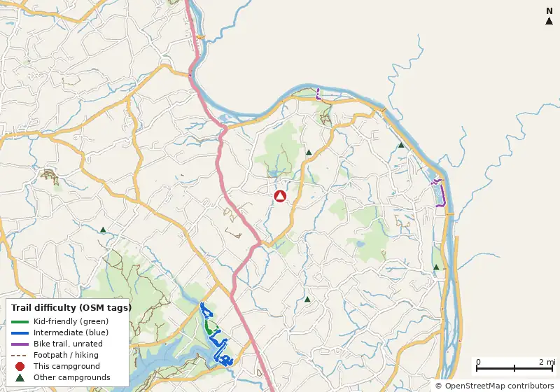
Loads MapLibre with OpenFreeMap tiles only when you tap.
How it compares
- There are 26 other campgrounds in our data within 25 miles.
- Straight-line distance: Philadelphia ~40 mi, Baltimore ~116 mi, Washington ~151 mi.
Amenities & rules
Dump stationFire ringsShowersToiletsTentsRVs/trailers
Trails within 5 miles
No named Forest Service or National Park Service trails are mapped within 5 miles. Trails on state, county or Corps of Engineers land aren't in these datasets.
Mountain biking nearby
10.2 miles of bike-legal trail lie within 5 miles (1.7 mi on unnamed paths). Difficulty mix: Family/Beginner: 1.8 miIntermediate: 6.8 miUnrated: 1.6 mi✓ Kid-friendly: 1.8 mi of green-rated trail
| Trail | Closest point | Miles within 5 mi | Difficulty (as tagged) | Kids | Source |
|---|---|---|---|---|---|
| Hammer Trail | 3.5 mi | 1.4 | Blue | OSM | |
| Tower Rd access trail | 3.8 mi | 0.1 | Green | OSM | |
| Cold Spot | 3.8 mi | 1.5 | Green | ✓ | OSM |
| Haycock Run | 3.9 mi | 0.6 | Green 0.2Blue 0.4 | ✓ | OSM |
| Eastern Woods | 4.1 mi | 1.4 | Blue | OSM | |
| Jay Walk | 4.2 mi | 1.5 | Blue | OSM | |
| South Park | 4.5 mi | 2.0 | Blue | OSM |
Ratings come only from OpenStreetMap mtb:scale / IMBA tags. Untagged trails show as "Unrated", and we never guess. Check conditions and maps on Trailforks or MTB Project.
Nearest campgrounds
| Campground | Miles | State | Fee/night | Sites | Hookups | Max RV | Pets | Booking | Trails ≤5 mi |
|---|---|---|---|---|---|---|---|---|---|
| Ringing Rocks Family Campground Cabins Private campground |
1.4 | PA | — | — | E S | yes | — | ? | 0 |
| Beaver Valley Campgrounds Cabins OpenStreetMap listing |
2.8 | PA | — | — | E S | yes | — | ? | 0 |
| Dogwood Haven Family Campground ↗ Private campground |
3.5 | NJ | — | — | — | — | — | ? | n/a |
| Tinicum Park Campground Private campground |
4.6 | PA | — | — | — | — | — | ? | 0 |
| Haycock Camping Ministries OpenStreetMap listing |
4.8 | PA | — | — | — | — | — | ? | 0 |
| Watt's Outpost Specialty Site OpenStreetMap listing |
7.0 | PA | — | — | — | — | — | ? | 0 |
Hookups: E = electric (max amps), W = water, S = sewer. "—" means the agency doesn't publish it. Trail counts are named USFS/NPS trails within 5 miles. 🟢 = kid-friendly (green-rated) bike trail nearby.