Buckhorn Gap Shelter and Campsite
Campground (listed in OpenStreetMap), North Carolina.
Summary
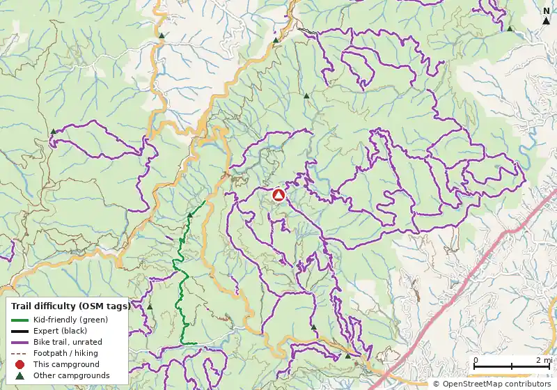
Buckhorn Gap Shelter and Campsite is a campground in North Carolina, about 21 miles (straight line) from Asheville. Within 5 miles there are 147.6 miles of trail open to bikes, the closest being Black Mountain Trail (at the campground), including 2 kid-friendly green trails and 1 expert-rated trail.
Map: trails and roads near Buckhorn Gap Shelter and Campsite
Loads MapLibre with OpenFreeMap tiles only when you tap.
How it compares
- There are 42 other campgrounds in our data within 25 miles.
- Straight-line distance: Asheville ~21 mi, Knoxville ~78 mi, Abingdon ~104 mi.
Amenities & rules
The agency hasn't published an amenity list for this campground.Tents
Trails within 5 miles
| Trail | Closest point | Mapped miles within 5 mi | Source |
|---|---|---|---|
| Buckhorn Gap | 0.1 mi | 5.9 | USFS |
| Black Mountain | 0.1 mi | 7.8 | USFS |
| Barnett Branch | 0.4 mi | 3.7 | USFS |
| Twin Falls | 0.6 mi | 0.5 | USFS |
| South Mills River | 0.7 mi | 12.4 | USFS |
| Avery Creek | 0.8 mi | 3.0 | USFS |
| Forest Discovery | 0.9 mi | 1.1 | USFS |
| Pink Beds Loop | 1.0 mi | 4.9 | USFS |
| Club Gap | 1.1 mi | 0.7 | USFS |
| Forest Festival | 1.1 mi | 0.9 | USFS |
| Buckwheat Knob | 1.1 mi | 1.4 | USFS |
| Clawhammer Cove | 1.3 mi | 1.1 | USFS |
+ 63 more named trails.
Mountain biking nearby
147.6 miles of bike-legal trail lie within 5 miles (0.9 mi on unnamed paths). Difficulty mix: Family/Beginner: 6.5 miExpert (double black): 0.6 miUnrated: 140.5 mi✓ Kid-friendly: 6.5 mi of green-rated trail
| Trail | Closest point | Miles within 5 mi | Difficulty (as tagged) | Kids | Source |
|---|---|---|---|---|---|
| Black Mountain Trail | 0.0 mi | 8.2 | Unrated | OSM | |
| Buckhorn Gap | 0.1 mi | 4.6 | Unrated | OSM | |
| Barnett Branch | 0.4 mi | 3.7 | Unrated | USFS | |
| Twin Falls Trail | 0.6 mi | 0.5 | Unrated | OSM | |
| South Mills River Road | 0.7 mi | 11.7 | Unrated | OSM | |
| Avery Creek | 0.8 mi | 3.1 | Unrated | OSM | |
| Forest Discovery | 0.9 mi | 1.1 | Unrated | USFS | |
| Club Gap | 1.1 mi | 0.7 | Unrated | OSM | |
| Buckwheat Knob | 1.1 mi | 1.5 | Unrated | OSM | |
| Forest Festival | 1.1 mi | 0.9 | Unrated | USFS | |
| Pink Beds Loop Trail | 1.3 mi | 2.4 | Unrated | OSM | |
| Clawhammer Cove | 1.3 mi | 1.1 | Unrated | USFS |
+ 66 more.
Ratings come only from OpenStreetMap mtb:scale / IMBA tags. Untagged trails show as "Unrated", and we never guess. Check conditions and maps on Trailforks or MTB Project.
Nearest campgrounds
| Campground | Miles | State | Fee/night | Sites | Hookups | Max RV | Pets | Booking | Trails ≤5 mi |
|---|---|---|---|---|---|---|---|---|---|
| Headwaters Roadside Campsites OpenStreetMap listing |
2.4 | NC | — | — | — | — | — | ? | 74 (170.9 mi) |
| Wolf Ford Horse Camp National Forests in North Carolina |
2.7 | NC | — | 11 | — | 50 ft | yes | Reserve | 60 (156.8 mi) |
| White Pine South Group Camp National Forests in North Carolina |
3.7 | NC | — | — | — | — | yes | Reserve | 53 (115.2 mi) |
| Mount Pisgah Campground Blue Ridge Parkway |
4.1 | NC | — | 126 | — | 80 ft | yes | Reserve | 47 (126.0 mi) |
| Cove Creek Upper Group Camp National Forests in North Carolina |
4.6 | NC | — | — | — | 35 ft | yes | Reserve | 74 (167.3 mi) |
| Cove Creek Lower Group Camp National Forests in North Carolina |
4.6 | NC | — | — | — | 35 ft | yes | Reserve | 74 (167.3 mi) |
Hookups: E = electric (max amps), W = water, S = sewer. "—" means the agency doesn't publish it. Trail counts are named USFS/NPS trails within 5 miles. 🟢 = kid-friendly (green-rated) bike trail nearby.